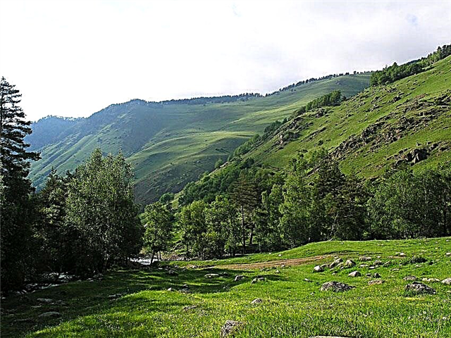
Belong to the basin of the Don and the Sea of Azov. Dry lands - rivers that dry up in drought, do not flow constantly. Voronezh region is located in the arid place of Russia. All the water in the region is concentrated in streams, rivers, reservoirs, ponds, lakes and swamps. Rivers are under ice in winter. They begin to open at the end of March.
The spring flood lasts two months. The river is fed mainly from the melting of snow. Rain and spring nutrition are present, but to a lesser extent. Autumn floods are even more noticeable on rivers than spring floods. In any case, the middle rivers of the region do not dry up and remain viable, unlike small rivers.
The longest rivers in the Voronezh region
List, photo with names and descriptions of the largest rivers in the region.
Don
This is one of the most beautiful and widest rivers of the Russian Plain. The width of the Don is from 40 to 80 meters. The river is typically flat. The source of the Don is in the Tula region. The regional center, the city of Voronezh, is located on the river. The right bank of the Don is high and white with chalk deposits. Not far from the village of Kostomarovo there are cave temples. Mineral springs were found in the village of Belaya Gorka. The mouth is the Sea of Azov.
The length of the river is 1870 km, in the Voronezh region - 530 km.

Read about the best places in the region: the main attractions of the Voronezh region.
Hopper
In addition to Voronezh, it flows through the Volgograd, Saratov and Penza regions. The source represents springs on the Kerensko-Chembarskaya Upland. It flows into the Don from the left side. At the mouth there is a village called Ust-Khoperskaya. The width of the Khoper in some places reaches 100 m. Among the historical monuments on the river there is the Museum of Nature of the Khopersky Reserve. It is located on the territory of the Raevsky estate. Two alleys of pines and poplars, which are more than a hundred years old, remain in the park.
The length of the river is 979 km, in the Voronezh region - 212 km.

Crow
It flows through three areas. The source is a spring near the village of Vedenyapino in the Penza region. The left bank of the river is higher than the right one. The banks are covered with oak forests, hazel. There are many lakes in the river basin. In the 50s, three hydroelectric power plants were built on the river. They are currently inactive. But the dams have not disappeared. They raise the waters of the river. There are many fish in the river. Tourists love to raft along the beautiful Crow.
The length of the river is 454 km, in the Voronezh region - 73 km.

Bityug
In addition to the Voronezh region, it flows through the Rostov and Lipetsk regions. It flows into the Don along the left bank. The river is famous for its abundance of fish. The right bank is higher than the left. The banks are swampy in places, overgrown with reeds. The 7 km section of the river between the villages of Ertil and Shchuchye is a hydrological monument. The river valley is covered with oak and pine forests. Very beautiful countryside and clear water attract lovers of water travel.
The length of the river is 379 km, in the Voronezh region - 293 km.

Voronezh
Two rivers: Polny and Lesnoy Voronezh, merging together, form the Voronezh River. The Voronezh River flows into the Don on the left side. The channel is a winding river with loops. The right bank of the river is the highest. The water in the river is clean. The bottom is sandy. One of the largest reservoirs with an area of 70 km² was built on the river in the city of Voronezh in the 70s of the XX century. It is currently heavily polluted. But before, the visibility in the water was 2-3 meters. The reservoir was used for underwater orienteering competitions.
The length of the river is 342 km, in the Voronezh region - 90 km.

Savala
The source is in the Tambov region. Savala is a left tributary of the Khoper River. The course of the river is calm, despite the winding channel. The banks of the river are ravine, overgrown with reeds. The river is used for irrigation of agricultural fields. The water is polluted by livestock complexes. But still the river is suitable for recreation, sports, fishing. The water is so clear that it allows you to shoot movies underwater.
The length of the river is 285 km, in the Voronezh region - 181 km.

Black Kalitva
The source of the river is located between the Papushin and Vlasov farms (Belgorod region). The river is fed by groundwater. Below the village of Krasnoe, the river flows through the Voronezh region. The banks of the river are swampy and impassable. As a result of the dissolution of chalk rocks, lying at a shallow depth, cavities are formed. It is not possible to build ponds in the river basin. Often, water from the pond goes into these cavities (karst). The estuary is on the right bank of the Don.
The length of the river is 162 km, in the Voronezh region - 102 km.

Silent Pine
The river originates from a small stream near the village of Pokrovka. And all over it is fed by springs and streams. The river flows through the Belgorod and Voronezh regions. The river has an ancient history. It was mentioned in the 17th century. The course of the river is so quiet that it allows you to hunt with fins and a speargun. Since 2009, sewage has been discharged into the river. The fish is dying. The water smells bad.
The length of the river is 161 km, in the Voronezh region - 63 km.

Usmanka
The source is located near the village of Moskovka in the Lipetsk region. Usmanka is a left tributary of the Voronezh River. The picturesque banks of the river are swampy. There are many lakes connected by channels. In summer, the river becomes shallow. To remedy this situation, dams were built. The Voronezh Nature Reserve is located in the river valley. The banks of the river, in the area of the reserve, are heavily overgrown with nettles, heaped up with aspen logs, not passable. The river serves for water supply of settlements, villages and cities through which it flows.
The length of the river is 151 km.

Tolucheevka
The source is located 2 km from the village of Verkhnetolucheevo. The estuary is on the left bank of the Don, 4 km from the village of Zamosc. The river is quiet, imperceptible, flows from north to south. Its width is about twenty meters. There is a lot of driftwood in the river. The bottom is sandy-clayey. The right bank is chalky and steep. Willows, blackberries, shrubs and grasses grow along the banks. Fish is found.
The length of the river is 142 km.

Tokay
The source of the river is located near the village of Rassvet (Tambov region) in salt licks. For about 28 km, the river slowly flows through the Tambov region. During drought, Tokaj dries up in several places. It flows into the Elan River, being its main tributary. The river bed is meandering. There is little forest on the banks. Basically, the banks are overgrown with bushes and meadow grasses. The ponds located on the catchment of the Tokai River are used for irrigation and fish farming.
The length of the river is 131 km., In the Voronezh region - 103 km.

Bogucharka
The source of the river is located in the Kantemirovsky district. The region of the Bogucharka river is a lot of hills with the outcropping of chalk deposits. The left bank of the river is steeper. The water level in the river is low. Bogucharka attracts local residents with its fishing spots. There are suspension bridges across the river. Herons and storks nest on the river. The flora and fauna of the river is not much different from the flora and fauna of other rivers in the region. The Bogucharka River is the right tributary of the Don.
The length of the river is 101 km.

Potudan
The river flows in the Voronezh and Belgorod regions. It flows into the Don from the right side. The source of the river is located near the village of Verkhnyaya Potudan in the Belgorod region. The Potudani floodplain is swampy. The width of the river reaches 15 m in places. Pine and alder forests and shrubs can be found along the banks. A large area is occupied by meadows. In the past, the water level in the river was supported by mill dams. Not far from the river is the Mostishchensky labyrinth. It is an oval 26 * 38 meters. Built from chalk rocks.
The total length of the river is 100 km.

Caviar
The source is located near the village of Sofyinka. Eight ponds have been built in the area to maintain high water levels in the river. Ikorets flows into the Don along the left bank. If you go from the city of Voronezh towards Rostov, then on the way there is a bridge over the Ikorets River. After the bridge, at the turn, there is a sanatorium named after V. Tsuryupy. There is the Ikorets mineral spring, beautiful places, beaches and the clear Ikorets river.
The length of the river is 97 km.

Hava
The source is located at a distance of three kilometers from the village of Verkhnyaya Khava. It flows into the Usmanka River. The banks of this narrow river are overgrown with bushes, reeds, burdock and nettles. Water lilies grow along the coast. The river carries silt, driftwood. The water is cloudy, with no signs of chemical contamination. But reclamation measures are needed, for example, a ban on longitudinal plowing of slopes in the Verkhnekhavsky district. There is fish in the river. The river is passable for kayaks. There are tourist centers along the river.
The length of the river is 97 km.

Karachan (Wet Karachan)
The source of the river is located 3 km from the village of Zapadnye Otruba in the Tambov region. It flows into the Khoper River on the right side. From the village. Krasnye Vyselki Karachan flows through the Voronezh region. It is currently a shallow river. Lack of forest along the banks is the main reason for the formation of ravines. The water in the river is muddy. But there is fish. Not far from the village of Verkhniy Karachan, archaeologists have discovered burial mounds.
The total length of the river is 95 km.

Veduga
The source of the river is located near the village of Malinovka, Kursk region. A narrow, winding river flows in steep, clayey banks. The villages along the banks stretch almost continuously. The bottom is sandy and silty. In some places, there are difficult-to-pass blockages of the riverbed with driftwood. There are five reservoirs on the river. Veduga flows into the Don. The river is not navigable, but it is suitable for leisurely kayaking.
The total length of the river is 94 km.

Osered
It originates in a swamp 5 km south-west of the village. Green Buturlinovsky district. The width of the river closer to the mouth reaches 3 km. It flows into the Don along the left bank. The river bed is winding. It then narrows to 2 meters, then expands. The right bank of the Oseredi is high, of chalk rocks. The left bank is more gentle. Deciduous forests grow in the forests: oak, maple, aspen, linden. The enterprises of the city of Buturlinovka and the animal husbandry of the region cause considerable damage to the river. The banks are littered. An unpleasant smell comes from the water.
The length of the river is 89 km.

Maid
The source is located in the village of Kuchugury, Nizhnedevitsky district. There are two rivers, the lower and the upper Devitsa. Both are the upper tributaries of the Don, and the Rossoshka tributary flows into each Devitsa. They are located at a distance of about 25 km from each other. The river runs through an area cut by ravines. In the lower reaches, refractory clay is mined. In dry years, the river dries up. In the 60s, a dam was built near Nizhnedevitsk. A reservoir with an area of 0.64 km² was formed.
The length of the river is 89 km.

Berezovka
It flows through the forest-steppe zone. Conventionally, Beryozovka can be divided into three sections. In the upper reaches there are many ponds. In the middle section, the right bank is higher than the left. Aquatic vegetation is found in the backwaters. Willow grows along the banks of the river. On the lower part of the coast there are steep, in some places there are ravines. In summer, the river dries up. Several dams have been built on it. The river is used for water supply and fish farming. The Berezovka River flows into Ikorets on the left side downstream.
The length of the river is 83 km.

Brushwood
The source is located near the village. Kolomenskoye. The estuary is on the left bank of the Don. The river flows through the Oka-Don lowland. The banks of the river are overgrown with reeds, bushes, cattail and sedge. There are three irrigation ponds in the village of Kashirskoye, up to 5 meters deep. And in other places the river is shallow. There is no forest on the banks. The fish is found in the area of the mouth.
The length of the river is 79 km.

Kurlak (Big Kurlak)
The source of the river is in the Ertilsky region in the Grechishnye Kusty tract. Kurlak flows into the Bityug River. The river basin is heavily indented by ravines. Kurlak is a typical small river. The channel is filled with water in spring during floods. The Kurlak bed is overgrown with reeds and gradually turns into a swamp. Due to the lack of flow, the river is naturally polluted, it “blooms”.
The length of the river is 78 km.

Chigla
The source is near the village of Kozlovka. Near the village of Staraya Chigla, the river flows into Bityug. The river basin is almost entirely occupied by arable land. In some places there are ravines. The river has gentle banks, the bottom is silty. One of the largest reservoirs has been built in the Talovaya gully. It is used for watering fields. There are about two hundred lakes and reservoirs in the river basin.
The length of the river is 75 km.

Rossosh
It flows into the Black Kalitva River. Rossosh is not a deep river, it dries up in places, freezes over. There are many ponds in the Rossosh basin. But only two of them hold water. In the upper reaches, the river valley is wide - up to 4 km. The right bank is very steep. The shores are clayey. The water in the river is muddy. These places are very good for fishermen. The river is home to pike perch, carp, silver bream and other fish.
The length of the river is 70 km.

Podgornaya
The source of the river is located near the village of Nikolskoye. The river flows into Tolucheevka. The river flows along the Kalach Upland. There are few forests in this area, the main part of the land is plowed fields. The right bank is high and steep. Near the village of Zamosc, the river is divided into branches. The chemical composition of the river is hydrocarbonate. The quality of the water is slightly polluted.
The length of the river is 68 km.