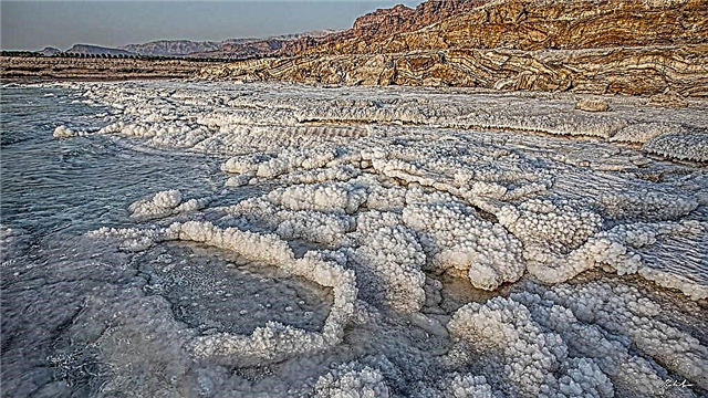
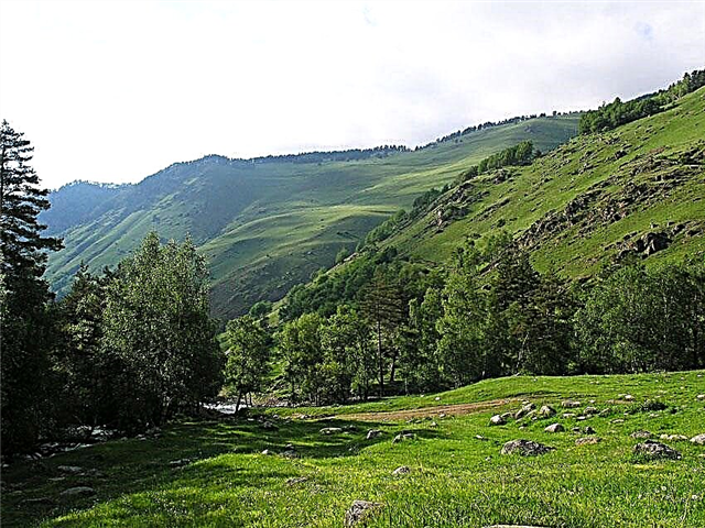
The Kostroma region is a land with unique nature, rich culture and history. Thanks to this, many beautiful places have been preserved here: untouched forests, clean rivers and lakes. More than 3000 rivers flow in the region, most of them are small rivers, and only 22 have a length of more than 100 km. The region belongs to the Upper Volga.
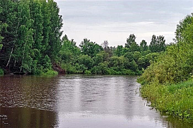
The main waterways are the Volga, Kostroma, Vetluga and Unzha. Of great importance in the region is the Gorky reservoir on the Volga, for its width it is called the sea. The peculiarity of the Kostroma rivers is predominantly forest character. As a rule, these are narrow bodies of water, meandering among the forests. They are rich in fish, able to surprise with unforgettable views and the smell of bird cherry in the spring. For this they are chosen by lovers of solitude and river travel.
The longest rivers in the Kostroma region
List of the largest rivers flowing through the region.
Volga
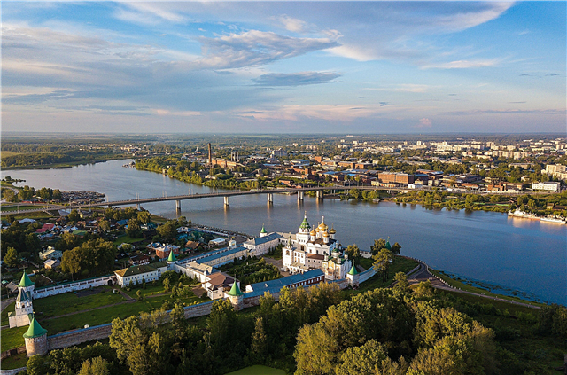
The Kostroma region belongs to the Upper Volga region. There are large ports on both banks of the river in the capital of the region. The city is located directly near the mouth of the Kostroma River - the left tributary of the Volga. At the confluence of the rivers, on the arrow, there is the famous Ipatiev Monastery. Many rivers and lakes of the region belong to the Volga basin. More than 15 species of fish live in them.
The length of the river is 3530 km, in the Kostroma region - 67 km.

Vetluga
One of the largest tributaries of the Volga, flows through the territory of four regions. In the Kostroma region on Vetluga there is the city of Sharya and the village of Vetluzhsky. In Sharya, timber harvesting is carried out, timber is transported along the river, and in floods 700 km from the mouth are navigable. The river flows among very beautiful places, the right bank is high. Vetluga is considered a paradise for fishermen, thanks to the purity of the water, even sterlet is found in it.
The total length of the river is 889 km.

Unzha
The left tributary of the Volga, originates in the Vologda region, from the confluence of two rivers. A significant part of the length of the river is located in Kostromskaya. It has a high right bank, on which there are many villages. The left bank is swampy, the channel width is about 60 meters. There are tourist centers, many places for recreation and fishing. It flows into the Gorky reservoir, forming the Unzhensky Bay. Near the mouth is the city of Yuryevets.
The total length of the river is 426 km.

Kostroma
The main part of the river, which gave the name to both the capital and the entire region, is located in the Kostroma region. On the border with the neighboring Yaroslavl region, there is only 50 km of the channel in the lower reaches. It originates from a swamp on the Galich Upland. At the beginning of the path it winds heavily among swamps and forests, the banks are high, in some places there are cliffs. There are rifts up to the middle. Then the river gains strength, spreading up to 60 meters wide. It flows into the Gorky reservoir in Kostroma.
The total length of the river is 354 km.

Not me
The largest tributary of the Unzha flows into it along the right bank 33 km before the mouth. It receives six main tributaries and several small ones; there are 32 lakes and reservoirs in the river basin. All along it flows through dense forests, in the lower reaches of the forest they become more rare. On it there are regional centers: the city of the same name and the village of Parfenevo. The river is popular with water tourists; in spring, forests are floated along it.
The length of the river is 253 km.

Vokhma
The right tributary of the Vetluga, originates from swamps near the border of the Kostroma and Vologda regions. The source is located in uninhabited forest areas. In the middle reaches and in the lower reaches of the river there are several settlements, including the large village of Vokhma. Often it bends, forming horseshoe-shaped bends and oxbows. The width is from 15 to 60 meters, the depth is shallow, about 2 meters.
The total length of the river is 219 km.

Mezha
The river passes through two districts of the Kostroma region. It originates in the Mezhevsky region, in the dense deserted forests from the confluence of two small rivers. The estuary is located in the Manturovsky region, where it flows into the Unzha along the right bank. At the very beginning, it is a small stream, thanks to the tributaries it is gaining strength and expanding up to 20 meters. The shores are partly wooded, there are beaches. Previously used for timber rafting, in some places it is clogged with logs.
The length of the river is 186 km.

Viga
It flows out of the swamps in the Chukhloma district of the Kostroma region, in the vicinity of the village of Kuryanovo. It flows on a wooded plain, often meanders, there are rifts. The channel is shallow, in summer it becomes very shallow, and in spring the level rises to 10 meters. The average width is 25 meters, the banks are steep. In the lower reaches it runs along the border with the Vologda Oblast. It flows into Unzha along the right bank near the village of Daravka.
The length of the river is 175 km.

Shuya
A small forest river, originates in the Antropovsky district of the Kostroma region. The channel is not wide, from 5 to 10 meters, very winding. Previously, timber rafting was carried out along it, there were blockages of trees. There is only one village of Kommunar on the river, the rest are abandoned. Used for river tourism, fishing. It flows into Nemdu along the left bank.
The length of the river is 170 km.

Tolshma
River on the territory of the Kostroma and Vologda regions. The source is located near the village of Khomutino in the Soligalichsky district, among local swamps. At first it flows in dense forests, winds strongly. Closer to the middle, it becomes wider, along the banks there are meadow areas. In spring it floods heavily, after floods new beaches often appear, the coastline changes. It flows into the Sukhona.
The total length of the river is 157 km.

Measure
The river originates in the Sudislavsky district of the Kostroma region, and only a small part of its length, in the lower reaches, is located in the Ivanovo region. The upper course of the Mera is a narrow meandering forest river in high banks, there are rifts. In the middle course it expands to 20 meters. On its banks are the Kostroma regional center Zavolzhskoe. It flows into the Gorky reservoir, forming a vast bay.
The total length of the river is 152 km.

Nemda
The source of the river is located on the Galich Upland, in the vicinity of the village of Palkino, Kostroma Region. First, it winds among the dense forests, then meadow areas appear along the banks, in some places the coast is swampy. All the way it passes through a very picturesque area along the Kostroma land, sometimes entering the Ivanovo region. In the backwater of the Gorky Reservoir, it overflows heavily, forming a picturesque bay with islands. There are many holiday homes here.
The total length of the river is 146 km.

Chobza
One of the largest tributaries of the Kostroma, flows into it along the left bank. It meanders among the forests, in some places there are meadows and swamps. There are beaches, but often the shores are rugged. Width up to 20 meters, depth - over 2 meters. On the river there is a large village Borok, famous for the ancient Iakov-Zhelezoborovsky monastery. Before the mouth it flows through a continuous deserted forest.
The length of the river is 140 km.

Solonitsa
This river is located in three regions at once. It starts from the swamps in the Ivanovo region, the main part of the path passes along the Kostroma, and flows into the Gorky reservoir near the village of Nekrasovskoe, Yaroslavl region. The river is known primarily for its mineral springs. Closer to the lower reaches there are many sanatoriums and rest houses. Also popular with fishermen. In the backwater of the reservoir it overflows heavily, here the river is navigable.
The total length of the river is 138 km.

Mesa
The source and the first few meters of the channel of this river are in the Ivanovo region, the rest of the length is in the Kostroma region. It is used both for fishing and for river rafting, there are many convenient places for recreation along the banks. In summer, it can overgrow, rifts are exposed. The Mesa is a calm small river that flows in low banks, often winds.
The total length of the river is 125 km.

Andoba
Left tributary of the Kostroma. It flows through three districts in the west of the Kostroma region. The source is in the Sudislavsky region, the middle course is in the Susaninsky, and the mouth is in Kostroma, near the border with the Yaroslavl region.An old chapel has been preserved at the mouth; they say that there was once a monastery here. The vicinity of the river has long been called the Andob camp. The river is calm, the channel often meanders, suitable for uncomplicated rafting and fishing.
The length of the river is 122 km.

The night
Right tributary of the Vokhma. It originates from the marshes in the Pavinsky district of the Kostroma region, at the very border with the Vologda region. The river valley is quite well populated, the largest village is Pavino. After 25 km from it there is an estuary: near the village of Petrushenki in the Vokhomsky district. The channel is not wide, the current is calm.
The length of the river is 119 km.

White Luh
The main part of the route of this river passes through the Makaryevsky district of the Kostroma region, in some places it enters the Nizhny Novgorod region. The source is located in the swamps south-west of the village named after Kalinin. It flows into Unzha along the left bank to the north of the village of Gorchukha. Previously, on the banks of the river there were settlements of one of the Gulag camps. The channel is not wide, it is clogged in places.
The total length of the river is 119 km.

Not me
The beginning of this river is located near the village of Ponazyrevo, where it is formed by the confluence of two small rivers. In the upper reaches, it partially passes through the Kirov region, but in the Kostroma region the main part of its path passes. Like her "older sister", it got its name for a very winding channel that winds its way through the forests. Width is about 20 meters. There are only two settlements on the river - Ponazyrevo and Panino, in both places there are bridges. It flows into the Vetluga along the left bank opposite the village of Konevo.
The total length of the river is 115 km.

Nelsha
The left tributary of the Nei is located in the Neisky district of the Kostroma region. From here water routes sometimes begin to Neya. There are several settlements on the river, including the city of the same name. The channel is shallow, the current is slow. The width is about 10 meters, in some places there are blockages of trees.
The length of the river is 114 km.
Shacha (tributary of the Kostroma)
The river originates near the village of Monakovo in the Galich district of the Kostroma region. It flows into Kostroma along the left bank in the Buisk region, 70 km before its mouth. It flows through picturesque places; sandy beaches are often found on the banks. A simple water route passes along it, with convenient parking and a small number of obstacles. There are both forest and open areas.
The length of the river is 113 km.

Ida
The river flows through two regions. It originates in the forests of the Vologda region, and the lower reaches and the mouth are in the Chukhlomsky district of the Kostroma region, where it flows into the Viga. Both of these rivers are often linked into a single route for river travel. The channel is shallow, with shoals and stones at the bottom. Fishermen celebrate good pike fishing here.
The total length of the river is 110 km.

Shacha (lower tributary of the Noli)
It flows into the Nolya River along the right bank in its lower reaches. On the same river in the upper reaches there is a tributary with the same name, but it is shallower and rather resembles a wide stream. The name translates to generous, fertile place. It originates in the Soligalichsky district, mainly flows through the territory of the Galichsky district of the Kostroma region.
The length of the river is 101 km.

Pyschug
The tributary of the Vetluga flows into it along the right bank, 9 km from the large village of Pyshchug, the regional center of the Kostroma region. This is an old village, part of the channel runs along its outskirts. The source is located in the forests on the border with the Vologda region. The main part of the river's path lies through dense forest. There are several settlements closer to the middle. The channel often bends.
The length of the river is 96 km.

Monza
It originates in the Vologda region, and only in the lower reaches it falls on the territory of the Buysky district of the Kostroma region. Right tributary of the Kostroma. The river is shallow, in the lower reaches the slope of the channel increases significantly. There are several rapids along the way. In these remote forest places, there are almost no roads, but the Monzenskaya railway passes.
The total length of the river is 96 km.

Poksha
The source and the first few kilometers of this river are in the Ivanovo region, but the main part of the route it passes through Kostroma. It flows into the Gorky reservoir in the Krasnoselsky region, the mouth is located slightly below Kostroma. There are rafting routes along the river, and people often fish here. Differs in the purity of the water. There is a moose farm in the village of Sumarokovo on Poksha.
The total length of the river is 89 km.

Big Sanga
A small river, its source is in the Ponazyrevsky district of the Kostroma region. The direction of the current is west, passing through a predominantly wooded area. In the lower reaches, the banks open up, and most of the settlements are located here. The largest of them are Bolshoi and Maly Poser. The estuary is located on the left bank of the Vetluga, 10 km north of the city of Sharya.
The length of the river is 87 km.

Kus
Right tributary of the Nemda. The name comes from the Finnish name for spruce. It originates in the Galich region. It flows through remote places that have preserved the historical memory of the rich past. This area is also called the Nizkusinskiy region. The channel is not wide, the depth is up to 2 meters. It receives several tributaries and flows into the Nyomda in the Kadyi region.
The length of the river is 86 km.

Veksa
It flows out of the very beautiful Galich lake - the largest in the Kostroma region. It flows westward through a treeless plain. The channel up to 40 meters wide is enclosed in steep, in places steep banks, often bends. Old-time lakes are found in the valley. From the headwaters to the mouth, the current slows down greatly. It receives several tributaries, the largest being the Nolya. It flows into Kostroma along the right bank.
The length of the river is 84 km.

Zero
It flows mainly through the Galich district of the Kostroma region. Thanks to the many springs feeding the river, it has clean cool water with a lot of fish. There are beaver dams. Zero is convenient for river rafting and hiking. There are many ancient villages with a rich history in these places. It flows into Vyoksa in the vicinity of the village of Voskresenskoye.
The length of the river is 84 km.